Your Integrated
Aviation Operations Hub
Ecosystem Partners

For Management & Operations Teams
An Ecosystem To Support Your Aviation Operation
Day Of Operations Suite
Optimising Flight Operations with Real-Time Management and Efficiency
Specialised OCC Services
Bespoke Solutions for Advanced Operational Control and Insight
Airport Operations
Enhancing Airport Safety and Reducing Incursions through Advanced Operations Management
Consulting Services
Driving Innovation and Efficiency with Specialised Aviation Consulting
SkyNet Features
REACH® Aero Software Suite

DAY OF OPERATIONS MODULES
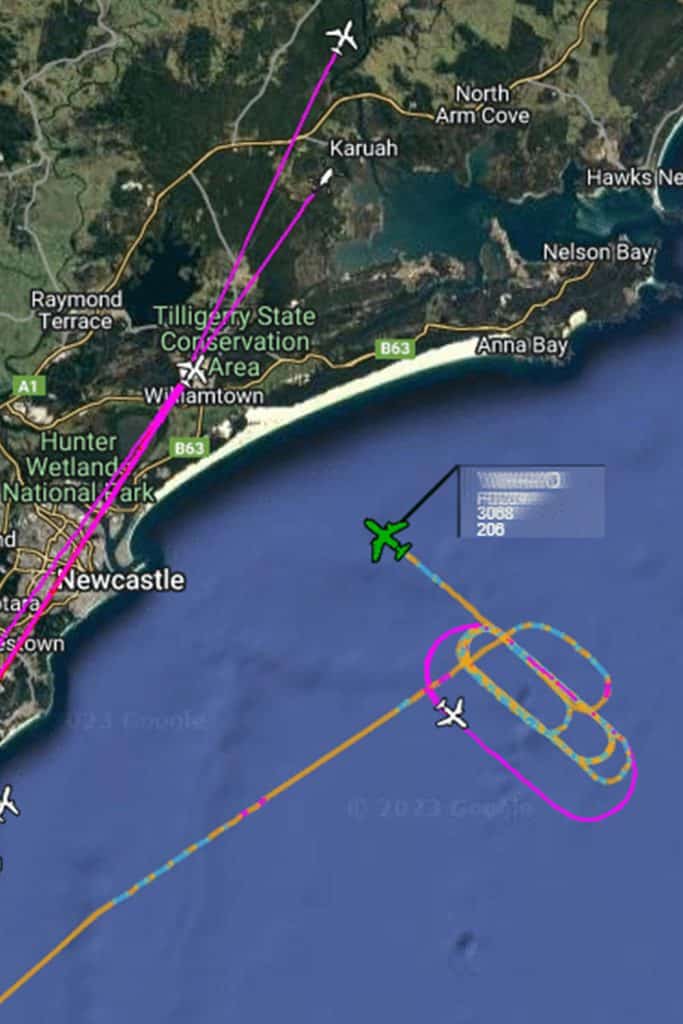
- Flight Monitoring
- Scheduling, Crewing and Rostering
- Flight Dispatch
- Critical Weather

BUSINESS ANALYTICS
- Fleet Management Business Analytics
- On-Time Performance (OTP) & Turn Around Reporting (TAR)
- Flight Information Display System (FIDS)
- Engineering Planning Support
Our Vision
Lorem ipsum dolor sit amet, consectetur adipiscing elit. Ut elit tellus, luctus nec ullamcorper mattis, pulvinar leo.
Our Mission
Vestibulum nisl justo, hendrerit nec consec tetur non, lacinia at quam. Nulla facilisi. Duis vulputate finibus consectetur.
Aircraft
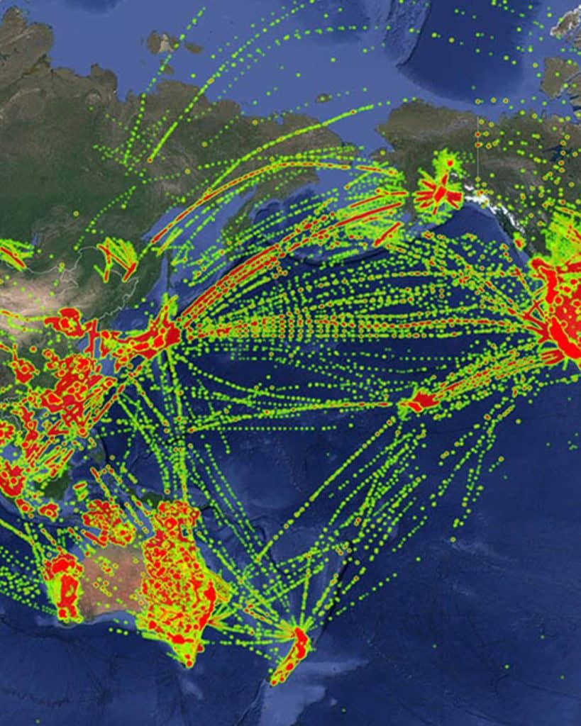
For 110+ Clients Across 47 Countries
TAKE THE OCC HEALTHCHECK
Find out your Operations Control Centre Benchmark
Lorem ipsum dolor sit amet, consec tetur adipiscing.
The SkyNet Approach
Take Command Of Your
Airline Operations
Flight Operations
Management & Control
Analytics & Reports
About SkyNet Aviation
Our aviation solutions unify the data feeds and reporting loops of all the silos and specialist departments needed to keep an air fleet operating safely, cost-effectively and smoothly.
The result is a holistic, coherent and interlinked real-time sit-rep of every little thing going on in every aircraft, cockpit, hangar, back-office and airspace sector that your operations touch. This data is then filtered and processed, turning the mass of information into clear and actionable insights.
Testimonials
Client Reviews

Ann Elliott
CEO of Aerlink
“Aerlink continues to expand our operations, supported by SkyNet Aviation’s REACH Aero. By their nature, our FIFO flight operations cover some very remote areas where communications are challenging and SkyNet Aviation has us covered the whole way with their technical innovations and ADS-B fusion tracking solutions”


James Barlow
CEO of Hevilift PNG
“Hevilift PNG operates a 35-aircraft mixed helicopter and fixed-wing fleet, contracting services across PNG and to Australia. We operate in extremely remote and rugged environments with highly challenging communications with the aircraft fleet. Our partnership with SkyNet Aviation is vital for flight safety and operational oversight. SkyNet’s continuous development progress has enabled significant improvements to safety and operational control.”


Alan Milne
CEO of SkyTrans
“Skytrans, now part of the Avia Solutions Group, has extended our multi-year relationship with SkyNet Aviation to provide their powerful REACH Aero platform as the foundation of our Integrated Operations Centre (IOC) as we expand. REACH Aero’s powerful integration with ForeFlight / Jeppesen Dispatch and ForeFlight Mobile, will support our expansion into the ACMI jet phase of our growth.”

Ian Sharples
Director of Flight Operations, ASL Australia
“As we expanded our operations, SkyNet Aviation has provided significant operations support and consulting, as well as our continued expansion of the REACH Aero operations platform.”
Our Team
Meet Our Expert Team
Lorem ipsum dolor sit amet, consectetur adipiscing elit. Aenean porta rhoncus leo, eget iaculis arcu dapibus vel. Lorem ipsum dolor sit amet, consectetur adipiscing elit. Proin porttitor, erat mollis, magna augue consectetur lorem.
Lorem ipsum dolor sit amet, consectetur adipiscing elit. Aenean porta rhoncus leo, eget iaculis arcu dapibus vel. Lorem ipsum dolor sit amet, consectetur adipiscing elit. Proin porttitor, erat mollis, magna augue consectetur lorem.
Lorem ipsum dolor sit amet, consectetur adipiscing elit. Aenean porta rhoncus leo, eget iaculis arcu dapibus vel. Lorem ipsum dolor sit amet, consectetur adipiscing elit. Proin porttitor, erat mollis, magna augue consectetur lorem.
Lorem ipsum dolor sit amet, consectetur adipiscing elit. Aenean porta rhoncus leo, eget iaculis arcu dapibus vel. Lorem ipsum dolor sit amet, consectetur adipiscing elit. Proin porttitor, erat mollis, magna augue consectetur lorem.
Lorem ipsum dolor sit amet, consectetur adipiscing elit. Aenean porta rhoncus leo, eget iaculis arcu dapibus vel. Lorem ipsum dolor sit amet, consectetur adipiscing elit. Proin porttitor, erat mollis, magna augue consectetur lorem.
Lorem ipsum dolor sit amet, consectetur adipiscing elit. Aenean porta rhoncus leo, eget iaculis arcu dapibus vel. Lorem ipsum dolor sit amet, consectetur adipiscing elit. Proin porttitor, erat mollis, magna augue consectetur lorem.
FAQs Page
Frequently Asked Questions
Lorem ipsum dolor sit amet, consectetur adipiscing elit. Vestibulum ut tortor nec mauris hendrerit sodales.
Phone
+61 7 3860 5511
Blog & Articles
From The SkyNet Newsroom

The Same, but Different – eVTOL Considerations for OCC Software
Electric Vertical Take-off and Landing (eVTOL) operations refer to the

Efficiently Navigating the Skies – The Power of Operational Intelligence in Aviation
Aviation is a dynamic business and therefore operational efficiency is

From Take Off to Landing and Then Some – The Importance of Record Keeping in the OCC
Our top ten list of why reporting and record-keeping should
Book A Demo
Request A Free REACH® Aero Demonstration
Discover how Reach® Aero can transform your airline’s operations